SOP’s for gliders at Logan Cache-Valley Airport (LGU)
General information for the airport may be found on its website:
Logan Cache-Valley Airport
Additional airport information can be found at the FAA Digital –Airport/Facilities Directory website. Type “KLGU” into the search box at:
https://www.faa.gov/air_traffic/flight_info/aeronav/digital_products/dafd/search/advanced/
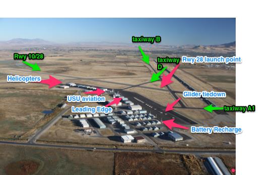
Utah State University has both fixed wing and helicopter flight schools located at the airport, and provide a majority of the traffic. The USU hanger is located on the ramp adjacent to Twy D. The helicopter school hanger is located at the far NW end of the ramp. The remainder of the traffic comes from a combination of private aircraft, corporate turboprop, and corporate jet.
Facilities
There is one FBO, Leading Edge Aviation, located at the field. Kim Hall, provides tow services and can be contacted at (435) 760-6752 or khall@leaviation.com.
Leading Edge Aviation currently is working on insuring one of their gliders for rent. Info will be posted when that happens. Bathrooms are located in the FBO and the airport provides a pilot lounge midway between the glider parking and the FBO. The pilot lounge is open to all pilots 24 hours, 7 days a week. It is located in hanger FL-6A and is indicated by a sign near the ramp. It has restrooms, internet access with a computer, and comfortable seating. Follow the sign midway down the north side of the hangar to the entrance.
One of our club members, Adam Kite, owns a hangar on the Logan Airport. It is hangar #C5, located west of the USA glider tiedown and just behind where the golf cart is parked. A room has been set up on the ramp side of his hanger. The room houses the battery rechargers and staging equipment for the Association glider. The room is secured by a padlock. The code to the padlock is the same as the code to the main gate for the airport. Oxygen can be purchased from Leading Edge Aviation. The USA is currently working on getting its own oxygen supply. Water can be obtained at a spigot located on the far south side of the ramp near the hangers.
Communications
CTAF is on 122.8 for all traffic and is the same frequency used at Morgan. ASOS is on 135.27. Tow plane communication, as well as all glider communications in the airport vicinity, are held on CTAF. 123.3 (glider common) can be used when flying on the ridge east of the airport.
Runways, Taxiways, and Windsocks
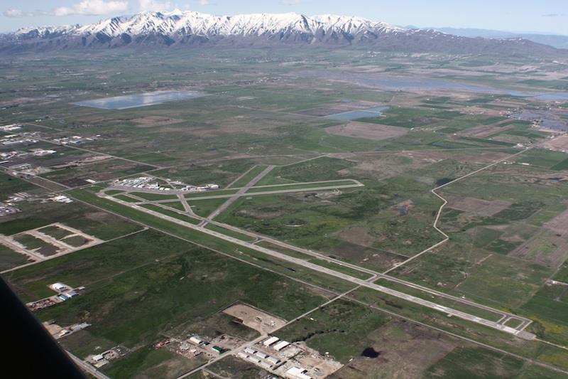
LGU has two primary runways, 17-35 (9010′) and 10-28 (4075′). There is also a closed and unmaintained asphalt runway that is suitable for an emergency landing in a glider. It is oriented 230-050 deg, is approximately 4000′ long and intersects Rwy 10-28 at midfield. The condition is deteriorating and there is now a taxiway light in the middle where it intersects Twy C.
Rwy 17 is the primary instrument runway for the airport and hosts the only precision approach, so the student traffic mainly uses that runway for instrument training. Both Runways 17 and 35 have non-precision RNAV approaches. Traffic pattern downwind for powered aircraft is located west of the airfield (when landing Rwy 35). The one published instrument departure at the airport departs from either Rwy 17 or 35 and turns west, heading to the LHO VOR located in Tremonton.
Glider operations are mainly held on Rwy 10-28. Preferred takeoff is Rwy 28, with the glider staging southeast of taxiway D in the overrun and is the calm wind runway. The airfield windsock is located just south of this departure point on the infield. Runway 10 is the preferred landing runway as it allows a quick turn to launch on Rwy 28 and reduces the conflict with powered traffic.
Taxiway traffic occurs mainly on Twys D and A1. When Rwy 35 is in use, most powered aircraft perform their preflight run up at the end of the ramp (adjacent to where the association parks its glider) and uses Twy A1 to enter the runway. The return to the ramp is on Twy D. When Rwy 17 is in use, Twy D is mainly used for both departure and return. Twy D is the main source of ground traffic conflict for glider operations.
Helicopter operations focus on Twy B and Twy C NW of the helicopter school hanger.
USA Glider Steward
Check the USA club website glider steward page or squawk book for information on who is the current glider steward.
Winter Operations
The Association plans to keep a glider operational throughout the year at Logan. Adam Kite has made room to store the glider in his hanger during the winter months. Contact Adam or the glider steward for training and access to the hangered glider.
Towing and Staging
Normally, the Association glider is staged from its parking spot with the golf cart using the east side of the ramp (taxiway A) and taxiway D to Rwy 28. Stage southeast of taxiway D in the overrun to be out of conflict with taxiing traffic. You can no longer access Rwy 28-10 from taxiway B. A tail wheel tow bar, as well as tow rope and wing wheel, is kept in the hanger room to use in staging. When staging on the runway, a courtesy call on CTAF is recommended. The golf cart can be parked well into the infield near the staging point for a return tow back to the tie-down spot.
Kim Hall is generally available during business hours for tows but prefers 24-hour notice. Call to confirm availability or to schedule on non-business hours at (435) 760-6752 or khall@leaviation.com.
Premature Tow Termination
Rwy 28 provides several options in the event of premature tow termination. At the end of the runway are several fields to the south, west and north. Care must be taken for a fence at the end of the runway, cattle in the fields and irrigation ditches running on the sides of the fields. Areas east and south of the airport are more congested with buildings and roads, although there are still some fields to be found. The closed runway is also an excellent option if a low break is encountered during the (normal) left-hand turnout.
Tow Patterns and Operations
Normal tow procedure is to turn left after a departure from Rwy 28, cross the arrival end of Rwy 35 and tow straight east to the mountain range. For pattern tows, the standard procedure is to launch on Rwy 28, turn left to pass over the Rwy 35 approach end, then turn north to fly parallel to, and east of, Rwy 17-35. After the release, the tow plane will land Rwy 28 and have time to clear the runway before the glider lands Rwy 10.
Airspace
Logan is located in Class E airspace with a floor of 700 ft. Traffic in the area is mainly VFR. Instrument traffic on arrival to SLC from the northeast is not a factor to glider operations. It is routed directly over Logan on the NORDK RNAV arrival but has a min altitude of FL190 until Brigham City (LHO).
Local Weather and Soaring Activity
Campbell Scientific has a weather station atop Logan Peak that gives accurate ridge soaring conditions. Find it at: Logan Peak Wind Speed and Direction.
The flying at Logan generally falls into three areas:
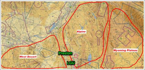
1. The Alpine region north and east of Logan. This area is characterized by green valleys and mountain ranges. The thermals are generally in the 4 to 8-knot range and fairly large and smooth.
2. The West Desert region to the west of Logan. This is drier and includes the northern flight areas of Ely. The thermals tend to be in the 6 to 10-knot range and smaller and rough.
3. The Wyoming Plateau region is east and southeast of Logan. This area is generally characterized by large cloud streets and high cloudbases. Be aware of the lack of landable sites and that the surface elevation rises to 7000 feet msl over most of the region. Usually, you are cruising at 14 to 18 thousand feet in this region. Also, getting back to Logan requires a glide over 30 or more miles of inhospitable terrain.
Most of the local soaring activity is along the Bear River mountain range east of the airport where the max terrain elevation is 10,000 ft. A good min altitude for leaving the ridge directly east of the airport for a no-wind return is 7000 ft. The closest airfield north of Logan and only other airfield in the valley is Preston, which is 22 miles north and has a 3400 ft paved runway. It shares the common CTAF frequency of 122.8 with Logan. Beware of its narrow and sharply crowned runway that has a sharp shoulder drop-off. You will want to end your rollout with your main off center to ensure your wingtip can be put down on the runway surface. If not, you will damage the underside of the wing.
Directions to the airport
When driving from the south/Sardine Canyon: From Hwy 89/91, turn left onto 10th West before reaching the city of Logan. Travel on 10th West till 25th North and you come to a T in the road. Turn right and the entrance to the airport will be immediately on your left.
From the west/ Tremonton: Travel east on the Valley View Highway until you reach 10th West (LWs Truck Stop). Turn left onto 10th West and travel north to 25th North and a T in the road. Turn right and the entrance to the airport will be immediately on your left.
From the north/Main Street: Turn west on 2500 North. The airport will be on your right.
After entering the airport, parking for the FBO will be straight ahead and to your right. To get to the association glider, turn right before reaching the parking lot and enter the hanger area thru the gate. The code can be obtained by calling the current glider steward. Due to security concerns, this code should not be shared outside of Utah Soaring Association.
Take your first left to access the ramp where the glider is parked. Use caution for aircraft while driving thru the hanger area. Cars can be parked in the gravel area next to the golf cart and glider room.
Mountain flying in Logan